
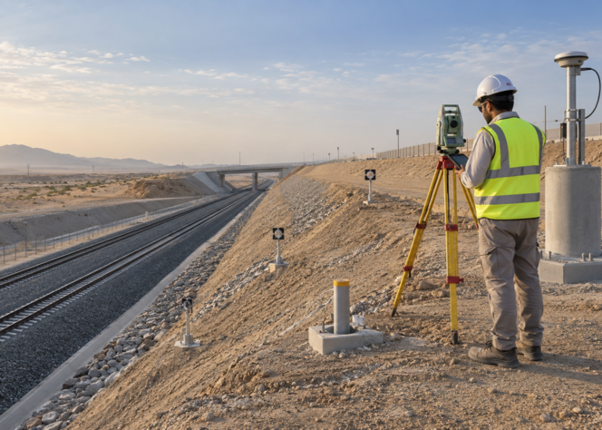
Slopes and Embankments Monitoring
Watch out for ground movement before it becomes worse.
Slopes and berms are found on roadways, trains, construction sites, dams, and many other infrastructure projects. Even if the earth looks solid, it might move due to construction, water, weather, traffic, or huge loads.
Even small amounts of motion might be significant if it continues over time.
You may see these changes by looking at the slopes and banks. “If we're tracking measures, we know if a slope or a berm is moving or settling or changing form.”
At Falcon Geo Monitoring, we apply surveys, monitoring techniques, and data analysis to provide project teams with a comprehensive image of what is happening on the site.
What are slopes and embankments?
Let's not overcomplicate things.
A slope is a rock or dirt surface that slants up or down. A slope can be either a natural hillside or an artificial one.
An embankment is an elevated bank of rock, earth, etc. used to support something such as a road or railway.
This is often where they are:
- Streets & roads
- Railway tracks
- Bridges and dams
- Sites of excavation
- Sites of building
- Mines and Quarries Construction
- Structures to control floods
These areas are the backbone of vital infrastructure, and it is interesting to study how they evolve.
Why should you be alert to slopes and embankments?
You don't always know when something is evolving on the hill.
Things can take a while to get moving. Today we have a tiny town; tomorrow we may have a big one. If the ground shifts, a small crack may move with it.
This is why it's necessary to have Slope Stability Monitoring UAE projects.
Monitoring the situation can help answer queries such as:
- Does the slope vary?
- Is the slope going down?
- Is the movement gaining momentum?
- Are the cracks growing worse?
- Does the construction impact the ground around it?
- Altering the groundwater?
Engineers can work out what's going on without just looking at things. Instead, they can employ metrics.
How do you survey slopes and embankments?
For slopes and embankments, monitoring involves frequent measurements and comparisons of measurements over time.
We were able to watch:
The way you monitor will depend on the project.
In some areas, standard surveys may be sufficient, but in others you require Real-Time Slope Monitoring, which means automated measurements are made all day long.
Remote Slope Monitoring can reduce the amount of physical checks that need to be done in hard-to-access locations.
Our services for monitoring slopes and embankments
At Falcon Geo Monitoring, we don't do the same monitoring setup for every job. First, we determine what you need to monitor, and then we select the correct technology.
Slope Stability Checks
We look for variations in the way the hill is moving and deforming to assist engineers in understanding what it is doing.
Slope movement monitoring
To determine whether the slope is moving horizontally or vertically, we measure changes in position.
Monitoring slope deformation
As time passes, we observe the change in the slope's shape or position.
Observation of Embankment Settlement
Once completed, new embankments can settle. We monitor this area and see how it changes over time.
Highway embankment monitoring
We monitor highway embankments during building and, if necessary, after the building is done to see if there is any movement or settling.
Monitoring of Railway Embankment
The rails must be on a stable base for the embankments to be stable. Tracking helps spot development or movement that nobody wants.
Observing the slope from afar
Remote systems can regularly collect monitoring data from sites that are hard to access.
Real-time automatic monitoring
The Automated Slope Monitoring system allows devices to measure autonomously and communicate data if movement becomes abnormal.
When is it helpful to watch slopes and embankments?
Monitoring is useful at nearly any point in a project.
Prior to Construction
Taking baseline measurements might assist you in understanding the condition of the location before you start working on it.
During the Construction Process
Ground can shift with digging, filling, heavy machinery, and building loads. Watching things indicates how the ground is responding.
Following the structure
Embankments can continue to settle after they are erected. Monitoring over time helps to trace this behaviour.
While the motorway is under construction
Roads and traffic may alter slopes and embankments. Monitoring helps to identify changes quickly.
Standard: Building the Railway
Railway embankments should not move too much, and the sides should be sturdy. Keeping an eye on them regularly gives you vital information about their health.
Close to existing buildings and infrastructure
Monitoring can be used to detect any unusual ground movements when construction is being carried out in the vicinity of existing structures.
When the weather changes
Rain and groundwater can affect the behaviour of the soil. Monitoring can identify changes in the ground conditions.
How is the slope and bank monitoring done?
The steps are not as hard as they sound.
We understand what you want to do with your project
We first look at the location, the work to be done, the terrain, any nearby buildings, and problem areas.
We show how to interpret
We decide what to measure, where to establish monitoring points, what sort of equipment to employ, and how often to measure.
Equipment is set
Depending on the work, we may utilise inclinometers, piezometers, monitoring prisms, GNSS, or other equipment.
We have readings starting with
The first readings get us started. This establishes a baseline against which future readings can be compared.
We collect information
The tracking plan tells us how we measure things. This could be on a regular basis or all the time.
We compare the findings side by side
We compare the new readings with the old ones to find out if anything has changed.
We look for trends
But just one statistic doesn't tell the complete story. When you look at data over time, you can see if movement is staying the same, increasing, or changing.
We tell you what we learned
The results can be presented as reports, graphs, tables, dashboards, or whatever format is required by the project.
Important updates we would want to bring to your notice
It can be flagged to the project team responsible for further investigation if monitoring data indicates movement that doesn't appear natural.
The Technology We Use
Each site needs tools in its unique way. The following tools for monitoring slope and embankment are used:
Prism and Total Station Monitoring
Used to measure how small the shift in position of certain points is.
Monitoring with GNSS
For larger locations, GNSS is beneficial since it tracks the location of monitoring points over time.
An inclinometer
These are used to see the movement of the ground underneath the surface. They may show the movement of the ground at different levels.
Piezometers
Piezometers measure the water pressure in the ground. This can allow engineers to understand changes in groundwater conditions over time.
3D Laser Scanning
A laser can scan the hill surface to create incredibly accurate 3D images. You can compare different tests to discover changes.
Drone Surveying
Drones may fly over large or hard-to-reach areas and capture photographs and information about the terrain from the air.
Surveillance of Computers
Readings can be taken at regular intervals with automated devices without a person having to take each one manually.
What are the benefits of this?
Its biggest benefit is that it is easier to observe what is happening on the pitch.
Regular checks will help you to:
- Move faster Search
- Settlement duration record
- Find out how slopes change.
- Search for odd movements.
- Be careful of large or difficult places.
- Eliminate unnecessary manual checks.
- Help make buildings safer.
- Ensure local infrastructure is secure.
- Make engineering decisions better.
Project Changes
Document all changes that occur in the project.
In simple terms, tracking gives you useful information.
What kinds of businesses do we serve?
There are a variety of different types of projects where it can be helpful to monitor slopes and berms.
Roads and highways
Surveying sides and slopes of roadways for habitation and movement.
Trains
Keeping an eye on the land around the tracks and the berms of the railways.
Buildings and bridges
Checking hills and berms surrounding huge construction jobs.
Building on
Ground conditions are vital to keep a watch on for excavation, earthwork and filling.
Dams and similar water structures
Watch for slopes and berms near buildings that are near water.
Mining and quarrying
Monitoring changes in shape and movement on steep excavation walls.
Industry Projects
Assisting in the monitoring of the demands of large industrial developments that take place on the ground.
What problems might arise?
Each project that needs monitoring has its unique issues.
Difficult to Reach
Some slopes are quite steep, far away, or in the centre of busy construction zones.
How we do things: We use drones, GNSS, remote systems, and automated tracking when it makes sense.
Much rain and water
The soil can behave differently depending on changes in the water.
Our approach: Movement and groundwater monitoring can be used jointly to yield a more complete picture of the site conditions.
Lots of space
There are perhaps plenty of places to look on a large hill.
Our plan: We can blanket the site rapidly using a mix of technologies.
Construction work
Ground movement can be produced by digging, traffic, machinery, and filling.
Method: We can observe how things are evolving as the project continues by taking baseline readings and monitoring things on a day-to-day basis.
Tons of data
Continuous surveillance creates a lot of data.
What we'll do: Clear data, dashboards, graphs, and automated systems, making it easy to understand large changes.
Why Falcon Geo Monitoring?
Monitoring accuracy, helpfulness, and ease of understanding.
Before we pick suitable equipment, we take the time to get to know your work.
What we provide you:
- Monitoring plans for a particular project
- New monitoring technology
- Getting the right information
- Expert tracking guidance
- Reporting, in general
- Remote monitoring solutions
- Automated monitoring systems
- Monitoring outcomes are straightforward to grasp
- Solutions for Build & Infrastructure Projects
It's not only what we do, but counting. We assist your project team in using that knowledge.
Watching slopes and embankments throughout the UAE
The UAE has a lot of major road, rail, construction, and infrastructure projects, and a lot of digging and building on top of the land.
These slopes and walls are subject to variation by construction, loading, weather, groundwater, and soil conditions.
Monitoring tools from Falcon Geo Monitoring enable project teams to stay up-to-date with these changes.
We provide customised services for your Slope Monitoring Services UAE project or Embankment Monitoring Services UAE project to meet the needs and conditions of your location.
Frequently Asked Questions
What is the effect of observing a slope?
When you notice a slope, you keep measuring it to see if it is moving, settling, or changing over time.
“Look at embankments” means what?
“Embankment monitoring” refers to the process of examining a constructed embankment for movement, settlement, and deformation.
Why should we pay attention to the stability of slopes?
It helps engineers understand how a slope is moving and notice any odd changes before they become difficult to deal with.
Can you see hills from a distance?
Yes. Remote Slope Monitoring can be done with GNSS, automatic total stations, sensors, drones, and other technologies.
How can you monitor slopes in real time?
Monitoring measurements are performed frequently enough, or continuously, to detect changes promptly.
How do you keep an eye on the building of embankments?
Settlement can be determined by using survey points, levelling equipment, GNSS, total stations, and other appropriate monitoring techniques.
How frequently should the monitoring be done?
Project Planning is not a one-size-fits-all exercise. It is contingent upon the site, the stage of development, the ground, the needs of the project, and how often it happens.
Can you view the sides of the highways?
Yes. Roadway Embankment Monitoring allows for monitoring of movement and settlement during and after the construction of a roadway.
Can you watch the sides of train embankments?
Yes. Embankment Monitoring for trains can help to monitor settlement, movement, and form change of land near rail infrastructure.
What tools are used?
Based on the project, the instruments that can be utilised are total stations, tracking prisms, GNSS, inclinometers, piezometers, drones, 3D laser scanners, and automated systems.
Do you provide slope monitoring services in UAE?
Yes, Falcon Geo Monitoring can monitor slopes, berms, roads, railways, construction sites, and other infrastructure projects in the UAE.